For cars to become successful, they first needed places to go. While rail networks helped modernise empires in the 19th century, it was through national highway construction programmes that many burgeoning 20th-century nation states sought to modernise.
At the beginning of the 20th century the number of limited-access highways in the world was zero; today, hundreds of thousands of expressways criss-cross the world, making highways collectively one of the largest building projects in human history. These networks have fundamentally altered the way people and goods move around, the way economies are governed, the way disparate geographies are connected, and the shape of a nation.
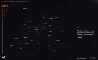
This visualisation, designed and developed by Studio Folder and Angelo Semeraro, reveals the history of their growth across Europe, intensifying in some regions during certain periods, while remaining stagnant or underdeveloped elsewhere.
Interactive features
Press play and watch the spread of motorways across Europe over the past 100 years. You can also explore the timeline, revealing key moments in motorway construction.

View the interactive map in night mode, add cities or trace the connection of motorways on and off mainland Europe by selecting the ferry button.

Download the dataset
The complete dataset used to create the visualisation can be downloaded from Studio Folder's GitHub repository.

